Metes and Bounds - X 64-bit Download
Popular x64 Tags
- autocad x64 download
- solidworks x64 download
- intellicad x64 download
- dxf x64 download
- dwg x64 download
- visualization x64 download
- cad x64 download
- architectural x64 download
- home x64 download
- design x64 download
- hpgl x64 download
- progecad x64 download
- animation x64 download
- fence x64 download
- cam x64 download
- dwg to pdf x64 download
- architect x64 download
- viz x64 download
- vrml x64 download
- convert x64 download
- gear x64 download
- landscape x64 download
- deck x64 download
- strength check x64 download
- batch x64 download
- garden x64 download
- yard x64 download
- gardening x64 download
- landscaping x64 download
- backyard x64 download
Metes and Bounds 6.2.4
Sponsored links:
license: Demo
downloads: 454
size: 35.50 MB
updated: 2024-12-04
tags: Metes and Bounds, download Metes and Bounds, Metes and Bounds free download, plot map, calculate square feet, calculate acreage, calculator, acreage, perimeter, Square Feet
Add to Basket
Sandy Knoll Software

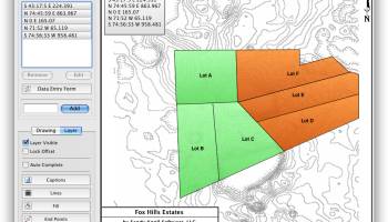
Metes and Bounds is a software that can create plot maps, perform calculations in square feets, acres, hectares, perimeter distance and more. Metes and Bounds turns data into a deed plot map. It can calculate square feet, acreage and hectares.
Enter measurements in rods, chains, meters, yards, inches, fathoms, hands, spans or furlongs. Angles can be given down to minutes and seconds. Can auto-close a plot drawing if the final plot segment is missing. Calculate area. Custom labels and backgrounds. Split single plots into multiple plots. GPS Waypoints and more.
The Drawing Wizard is an optional way to start a new drawing. It will ask you several questions about what type of drawing you plan on creating. Based on your answers to these questions, the wizard will preset some of the drawing values to help you accomplish your goals.
FEATURES:
· Perform calculations: Square Feet, Acres, Hectares, perimeter distance and more.
· Easy to use data entry form: Enter lines or curve data.
· Layers: Layers allow you to have multiple deeds on a single drawing. Layers can be free floating or locked to a common starting point.
· Metes & Bounds will calculate if the survey closes or not. Calculate closure errors.
· Auto-Completion of drawing. If you're missing the final segment of your land plotting data, let our Metes and Bounds land plotting software finish it for you. Have a bad or missing call? Enter a question mark (?) for the call and let the software find the missing call for you.
· Multiple measurement types: Data can be inputted using Feet, meters, rods, chains, varas and many other measurement types
· Easy to use measuring tool. Estimate the distance between any two points on the screen.
· Automatic labeling: Each line can be automatically labeled with the length and call. End points can be marked for easier recognition. End points can also be labeled with information like the interior and exterior angles.
Create custom labels and backgrounds. Labels can be rotated in 90 degree increments. Drawings can include a call list:
· Backgrounds can be set to scale with your plot drawing.
· Split a single plot into multiple plots. Split the plot by hand, or choose a starting point and let the Metes and Bounds software find the nearest halves automatically for you.
· Create section drawings.
· Exporting: Metes and Bounds data can be exported as a DXF file, KML File, CSV file and more.
· Printing: Printouts can include borders, call list, north arrow and title block.
· Real-world X,Y coordinates. Export real-world X,Y coordinates for integration with other mapping software such as GIS software.
· Custom X,Y points. Use custom X,Y points to mark and label unique land features on the metes and bounds drawing.
· Real-world Latitude and Longitude coordinates. Enter the latitude and longitude for a plot's POB and let the metes and bounds software calculate the latitude and longitude for each of the other end points.
· Waypoints to metes and bounds calls. Convert a set of waypoints, x/y or Latitude/Longitude based, into a list of metes and bounds calls.
· Enter Waypoints and Tracks. Add GPS waypoints and tracks to your drawings. Import GPX and KML files. Make calculations like the distance between two waypoints.
OS: Windows 11, Windows 10 32/64 bit, Windows 8 32/64 bit, Windows 7 32/64 bit
Add Your Review or 64-bit Compatibility Report
Top CAD 64-bit downloads


AdvancedHMI 3.99x Patch 3
A free software used to build HMIs that display information residing in a PLC
Open Source


DAVID-Laserscanner 5.6.0.2037
A freeware software that allows you to scan/digitize three-dimensionals objects
Freeware

20sim Viewer 4.8.4
A modeling and simulation program that runs under Microsoft Windows
Demo | $700.00
Members area
Top 64-bit Downloads
-
CurveExpert Basic 2.2.3
x64 trialware download -
iuVCS Deluxe x64 0.14.0.63
x64 trialware download -
LuxRender x64 1.6.0
x64 freeware download -
Vextractor x64 7.20
x64 shareware download -
Voxengo Span x64 3.20
x64 freeware download -
Photo Ninja 64-bit 1.4.0c
x64 trialware download -
LazPaint x64 7.2.2
x64 open source download -
ImageMagick for Windows
(x64 bit) 7.1.1-34
x64 freeware download -
TopSpice 10.26a
x64 demo download -
Potrace for Windows (x64
bit) 1.16
x64 open source download
Top Downloads
-
CorelDRAW X6 16.4.0.1280
trialware download -
CorelDRAW X5 2025 26.0.0.101
trialware download -
TinyPDF 3.00
freeware download -
PDF to Flash Brochure
(Pro) Spread Theme:
Brilliant 1.0
freeware download -
Imagelys Picture Styles 11.20.0
freeware download -
QtGrace 0.2.6
open source download -
CorelDRAW X8 18.0.0.450
trialware download -
Texmod 0.9b
freeware download -
CurveExpert Basic 2.2.3
trialware download -
PhotoPad Photo Editor
Free 14.11
freeware download -
ACDSee Photo Studio
Ultimate 18.1.0.4072
shareware download -
ORS Visual Lite 1.5.1
freeware download -
Roxio 3D Photo Creator 1.0
trialware download -
FreeCAD Portable 0.21.2
open source download -
ACDSee Photo Studio Home 28.1.0.3032
shareware download